Transportation
There are many ways to get around Denver. Whether you live on campus or thirty minutes away, below are some helpful links and information about transportation in the Denver Metro area.

Public Transportation
All MSU Denver students receive a pass for public transit. Your student fees cover the cost of your ECO Pass. You can pick up your RTD pass on campus in Tivoli Station (Bookstore), located on the second floor of the Tivoli Student Union. The pass will remain valid every semester you are enrolled in classes. Learn how to pay and active your CollegePass here.
You can utilize RTD’s Trip Planner to find the quickest route to your destination. There is also an app available for smartphones on the Google Play Store and the App Store.
Whether you live on campus or 30 minutes away, use the links and information below to navigate transportation in the Denver metro area:
🚆RTD Lightrail System
The RTD rail system operates 365 days a year. Eight rail lines service 53 stations along the Denver's North, East, Southeast, Southwest, and West rail corridors. There are two convenient lightrail stations on the edges of campus for easy access.
🚍RTD Bus System
The RTD bus system operates 365 days a year, offering service at more than 10,000 bus stops across eight counties in the Denver metro area. There are multiple bus lines that run near or through campus for easy access.
Driving & Parking on Campus
There are over 15 parking lots and garages on the Auraria Campus. There are options to pay by the hour or purchase a parking pass.
Click the image below to locate specific parking lots or download the Parking Map of Auraria Campus.
To learn more about pricing of each lot, visit AHEC Parking and Transportation.

Ride Sharing & Car Services
Denver locals utilize these ride- and car-sharing services:
Biking
Denver and the surrounding suburbs are bicycle-friendly. Explore the Denver Bike Map. Combining bikes with transit makes it even easier to get around! RTD's bus and rail system serves commuters, avid cyclists, and city cruisers alike. You can take advantage of RTD bike and ride by bringing your bike on the light rail or buses.
Bicycle Registration
Everyone is encouraged to register their bike with the Auraria Campus Police Department.
Auraria Sustainable Campus Program (ASCP)
The ASCP provides information for bicyclists on their including a Bike Aware Guide, and a Biking on the Auraria Campus Guide.
Covered Bike Parking
There are three covered bike parking options on campus:
- Tivoli Parking Garage (first floor)
- Two bike shelter locations: the 10th St Plaza (by the Arts Building) and on Larimer St. (next to the North Classroom Building)
Learn more about how to get your card encoded for covered bike parking >
🚴 Bicycle Safety Tips
- Register your bike
- Park at designated bike parking
- Always use a u-lock to secure your bike
- Be aware of your surroundings
- Wear a helmet Ride your bike as you would drive a car
- Always obey traffic signals and signs
- Be conscious of pedestrians, and give audibles like "On your left!" to announce your presence
- Avoid wearing headphones
- Use front and rear bike lights
- Use hand signals to indicate turns
Filter Off-Campus Apartments by Commute and Transit Access
Looking for a place near public transportation? Whether you plan to walk, bike, take the bus or light rail, or simply want an easy commute to campus, our off-campus housing search tools make it simple. Use the transit map filters to find apartments close to Denver bus and light rail routes, so you can get to class, work, or campus activities quickly and conveniently.
#1: Plan Your Commute Tool
Once you find a property you like, use the integrated Google Maps tool on the listing to explore your potential commute by car, walking, biking, or public transit. You can also choose specific points of interest on campus, such as classroom buildings, labs, or the student center, as well as local spots like restaurants, grocery stores, gyms, and more to see directions from your potential future home.
Use the instructions below to start planning your commute:
- While viewing a property's listing page, scroll down to the Google map found under Amenities, called "Map of [property name]."
-
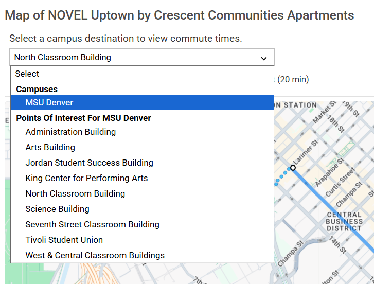
Select your campus (e.g., MSU Denver)
-
If you have a specific building or location on campus you'd like to map to, select it from under the Points of Interest For MSU Denver dropdown options:
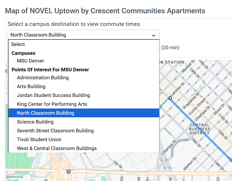


Note: It's possible that not all campus buildings will appear in this list. If you know of another nearby building in the list, you can use this as your destination for a similar estimated commute time. If you’d like to suggest a building to add, we’d love to hear your feedback. Simply submit a request here, select I would like to suggest a feature, enter: "On-Campus Point of Interest suggestion: [suggested building name]," and our team will review your request!
-
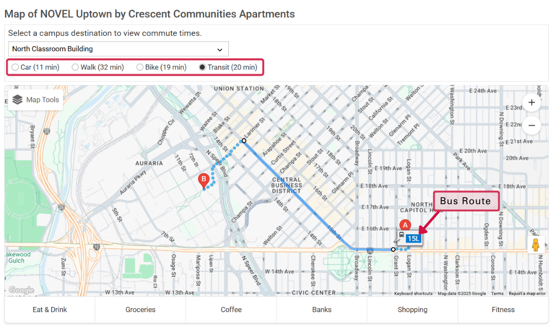
Choose transportation method (Car, Walk, Bike, or Transit):
-
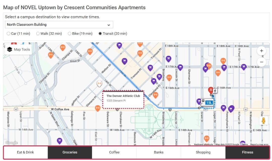
You can also view other nearby stops along your route by selecting one or more options at the bottom of the map:


#2: Public Transportation Map Tool
Adding this map overlay to the housing search map can provide a general visual of Light Rail routes and station locations while you browse available apartments near campus.
Note: This feature does not show every bus stop or route. It provides a general overview of major rail lines to help you narrow your housing search and find options near public transit.
For more detailed route planning and maps, see #1: Plan Your Commute Tool.
Here's how you can use this tool:
💻 Desktop
- Go to the Housing section from the top toolbar
- Click Map Tools in the top-left corner of the map
-
Select Public Transit to see bus and light rail lines
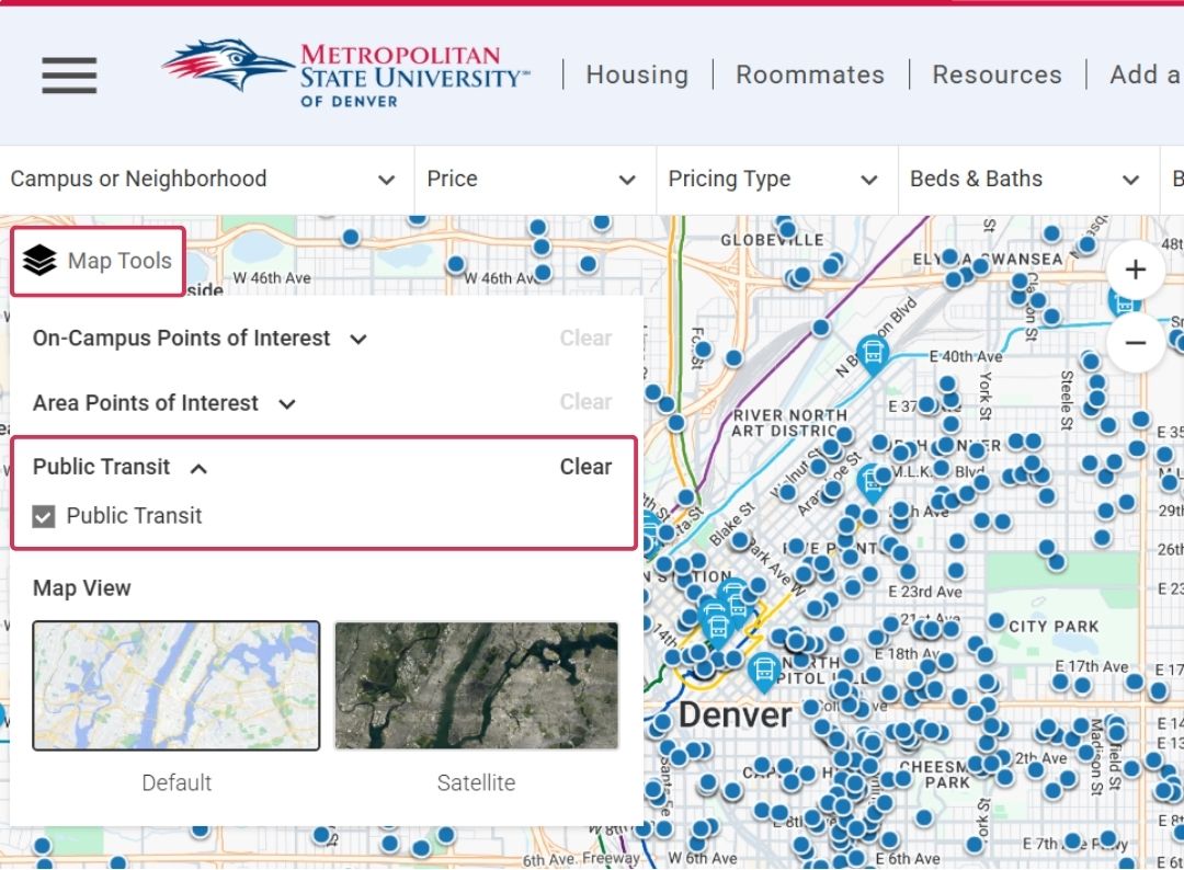
-
Click Map Tools again to close the pop-up menu and view your search results
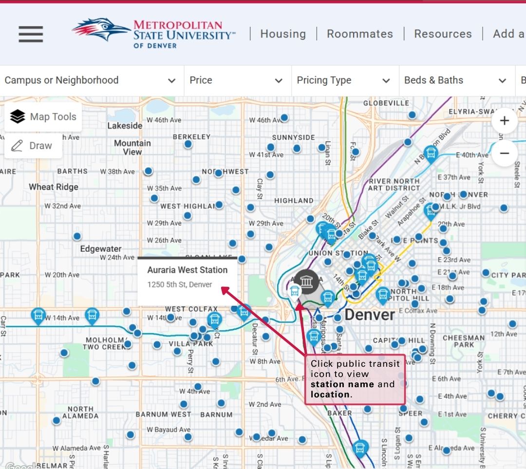
Select any public transit icon to view the station’s name and location.


📱 Mobile
- Open the Housing section
- Make sure you're in Map View (instead of 'List View') in the top-left corner so the map is visible
- Tap Map Tools in the top-right corner
- Select Public Transit
-
Tap Done to close Map Tools and view your search results:
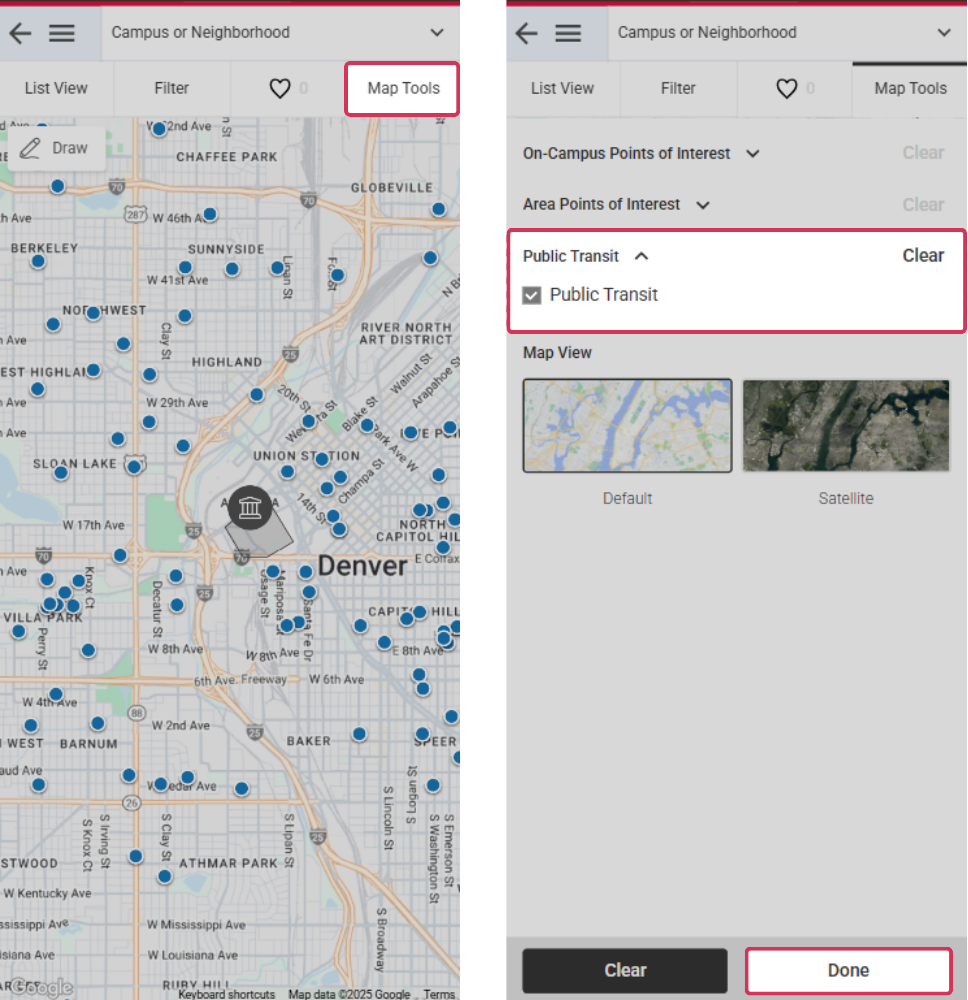
Map Tools (Mobile View)

#3: Search Filters
Filter properties on the housing search page under More (located on the top-right toolbar) and make your selection, or select from these prefiltered search options:
| Properties Within 1 Mile of Campus > |
| Properties Within 2 Miles of Campus > |
| All Properties, Sorted by Distance to Campus (Closest First) > |
| Properties Near Metro or Subway > |
| Properties Near Bus Stop > |
Have Questions?
We're here to help! If you have any questions about using the search filters or tools, please send us an email or call (877) 895-1234 anytime.